Our High Road Leytonstone


High Road Leytonstone is one of the borough’s most important high roads, linking Leytonstone and South Leytonstone with Maryland and Stratford. The road is home to many residents, vibrant small businesses, and community hubs like Leytonstone Library.

What's happened so far

In 2021, we asked you what the area should look like in the future and used this information to create the South Leytonstone Area Framework. Some of the key priorities raised included activating High Road Leytonstone by improving public spaces and making it easier to walk and cycle to key transport hubs and nearby town centres.

In November 2025, we asked you for more detailed thoughts and feedback on High Road Leytonstone and where improvements needed to be made to make the high street safer and healthier, creating a place for everyone to enjoy and businesses to thrive. You told us:
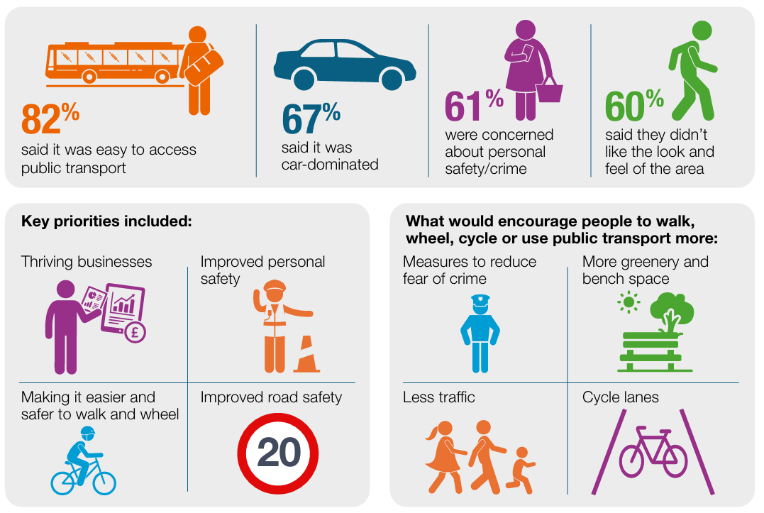
Infographic summarising public consultation findings for High Road Leytonstone. Key findings: 82% said public transport was easy to access; 67% felt the area was car-dominated; 61% were concerned about personal safety and crime; and 60% disliked the look and feel of the area. Priorities identified were thriving businesses, improved personal safety, making walking and wheeling easier and safer, and improved road safety. Measures that would encourage more walking, wheeling, cycling and public transport use included reducing fear of crime, adding more greenery and seating, reducing traffic, and creating cycle lanes.

We also visited businesses and asked them about their loading and access requirements:
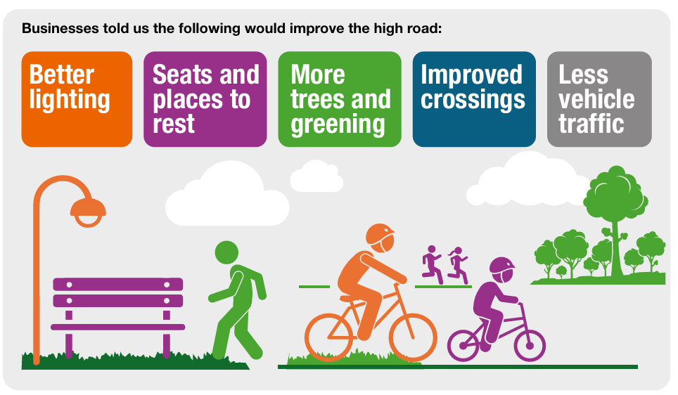
Infographic showing what businesses said would improve the high road. Suggested improvements are better lighting, more seats and places to rest, more trees and greenery, improved crossings, and less vehicle traffic. Illustrations include a streetlight, bench, pedestrian, cyclists, runners, and trees in a greener streetscape.

We wanted to find out how people travel on the high road, so we commissioned independent surveyors to ask them:
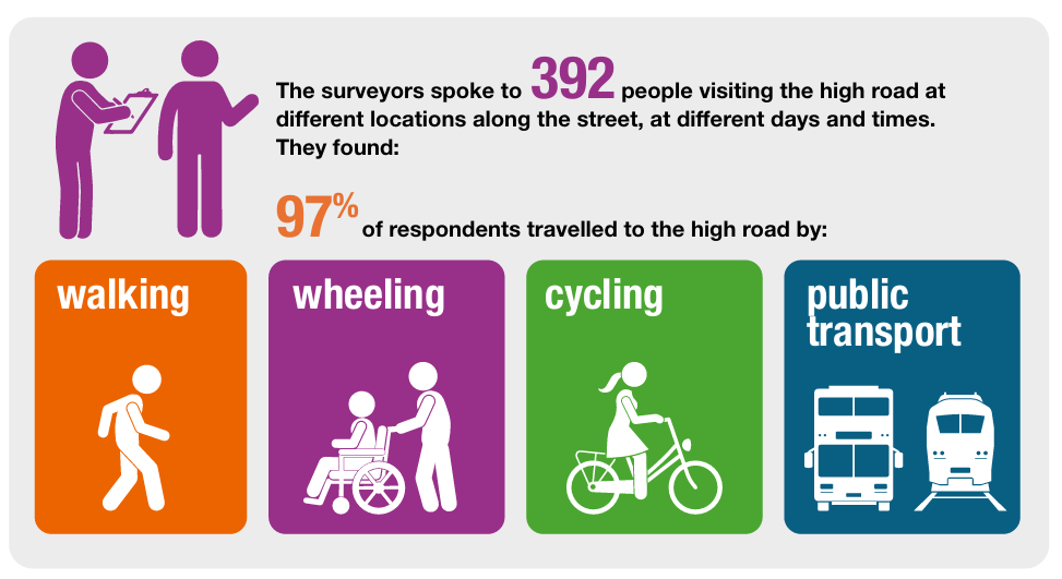
Infographic showing intercept survey results from High Road visitors. Surveyors spoke to 392 people at different locations, days and times. The survey found that 97% of respondents travelled to the high road by walking, wheeling, cycling or public transport. Illustrated icons represent each travel mode.

Using your feedback and the data we collected, we’ve developed plans which include safer crossings, protected cycle lanes, new trees and planting, improved public spaces, and changes to parking and loading. We want to know what you think to help shape the final scheme.

What we are proposing

We’ve used the feedback and data collected so far to create proposals for High Road Leytonstone which include:

  • A protected cycle track on both sides of the road from Church Lane to Wingfield Road, connecting the existing cycleway introduced in 2023 from Gainsborough Road to Bush Road to the borough boundary with Newham. In the longer term, this should connect with proposals being developed by Newham Council for Leytonstone Road.
  • New continuous footways on seven side roads and upgrades to seven existing continuous footways. Continuous footways are where the pavement continues across a side road, making it easier for people to walk, wheel, or use pushchairs. The design helps slow vehicles as they enter or leave the side road and makes it clearer that drivers should give way to pedestrians crossing, in line with the principles of the Highway Code.
  • Landscaping and 46 new trees. While about 29 trees will be removed, the scheme will result in an overall increase of 17 trees across the area. These numbers may change, depending on the final design.
  • Cycle bypasses at bus stops to provide a protected cycle route along the length of the scheme. At these stops, the cycle track would pass behind the passenger waiting and boarding area. Tactile paving, designated crossing points and large pavement areas would help passengers cross the cycle track and wait for buses safely.
  • Four new crossings in response to requests, to better connect the areas either side of the high road. Upgrades to all existing crossings so cyclists can cross safely too.
  • Six improved public spaces, with consistent design, planting and materials to make the area more welcoming at: Southwell Grove, Mayville Road, Harrow Green, Denmark Street, Crownfield Road and Jubilee Gardens.
  • Introducing one-way operation on six side roads to reduce vehicle conflicts and improve safety near crossings, bus stops and junctions with poor visibility at: Barclay Road, Michael Road, Victoria Road, Thorne Close, Eve Road and Borthwick Road.
  • Creating a new signalised junction at Harrow Green and upgrading existing signalised crossings at Cathall Road and Crownfield Road to include crossings for cyclists. Signalised junctions are those with traffic lights.

Detailed plans of the proposals and visuals can be found can be found in the documents section of this page.
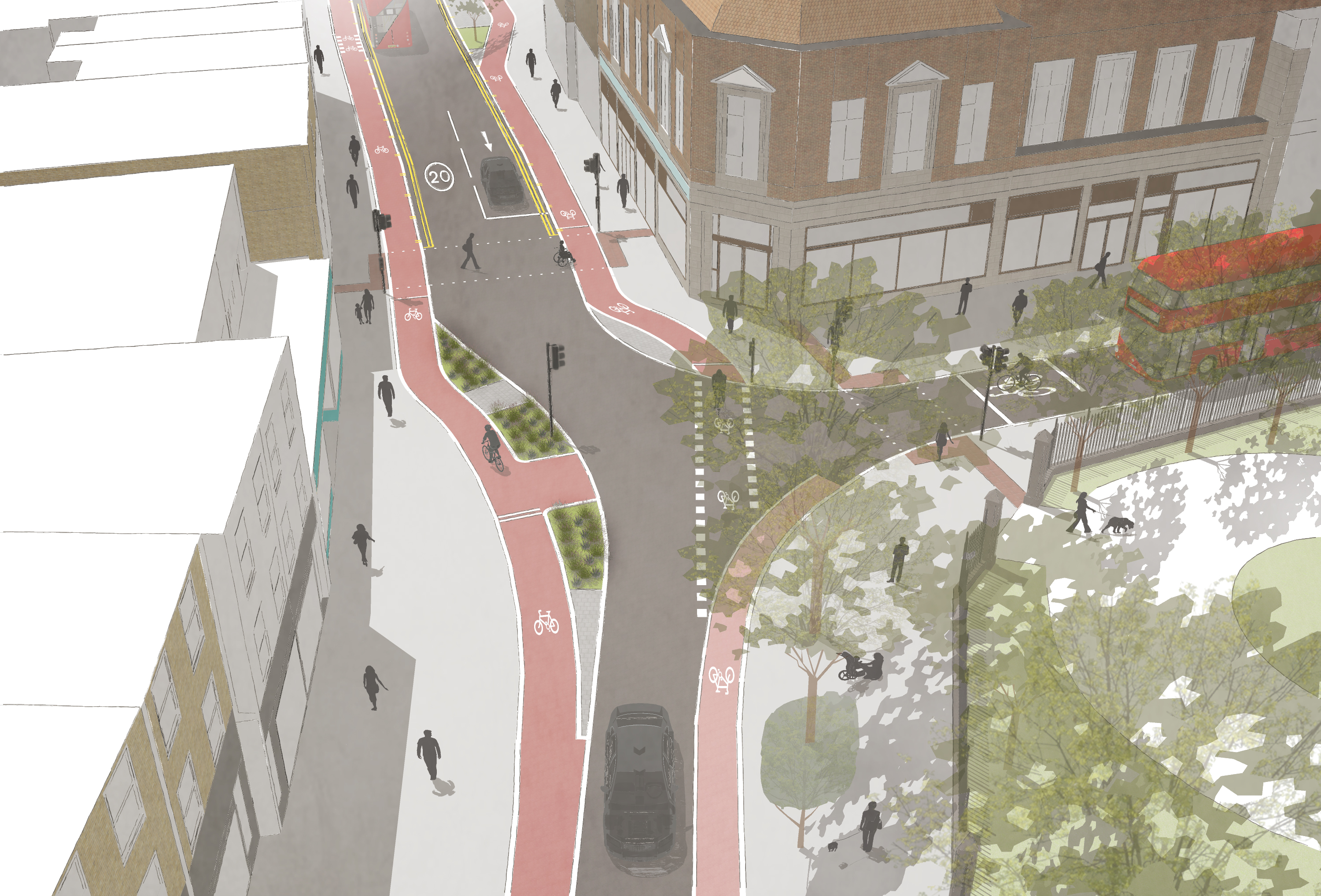
Visualisation of High Road Leytonstone and Church Lane
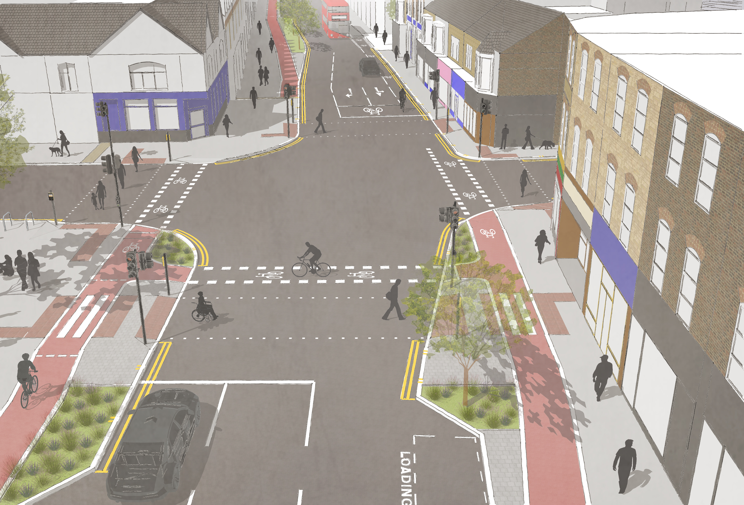

Visualisation showing High Road Leytonstone with protected cycle tracks on either side and spaces for low level planting.

Visualisation of High Road Leytonstone and Crownfield Road
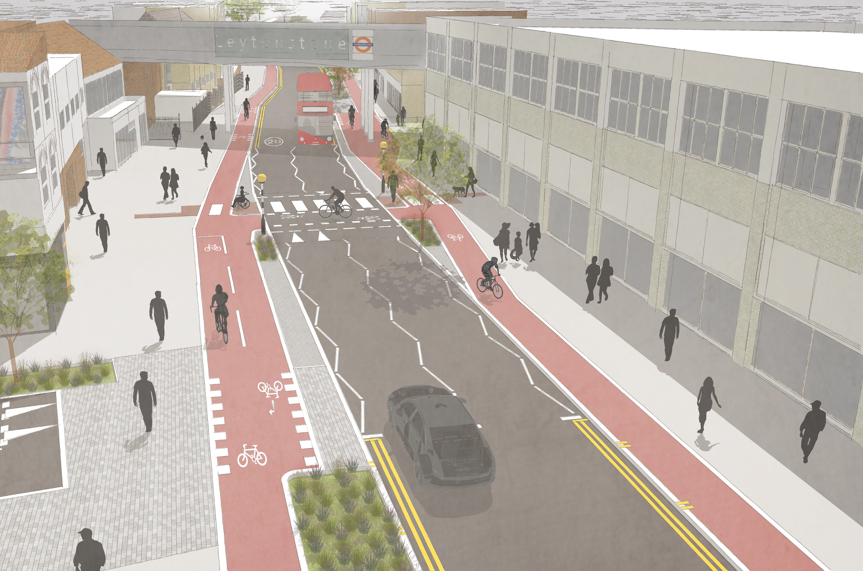

Visualisation showing High Road Leytonstone with protected cycle tracks on either side, a zebra crossing and spaces for low level planting.

Visualisation of High Road Leytonstone and Ferndale Road
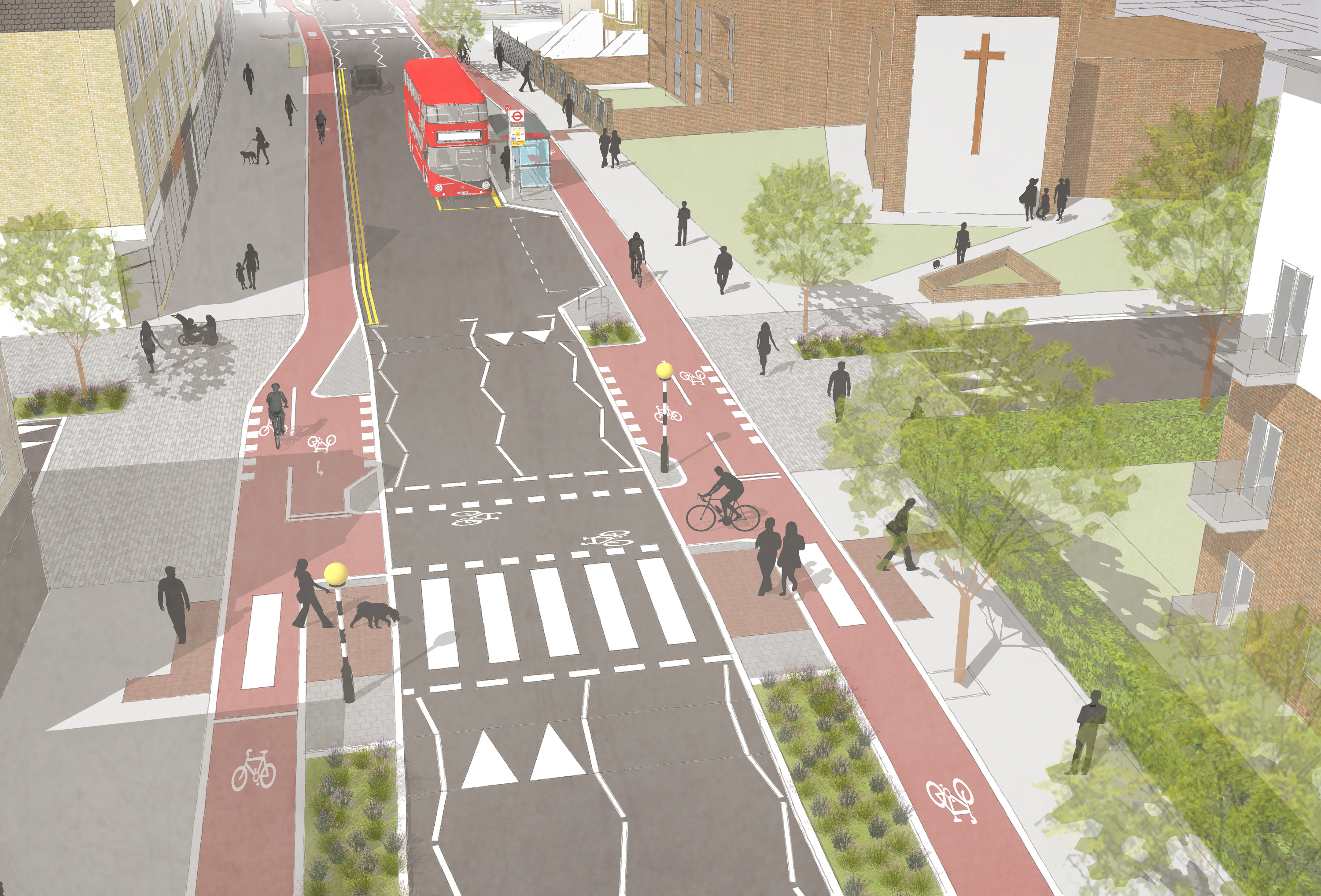

Visualisation showing High Road Leytonstone with protected cycle tracks on either side, a zebra crossing, a cycle bypass and spaces for low level planting.Visualisation of High Road Leytonstone and Lister Road


Parking changes

To deliver the proposed improvements, some parking spaces would need to be removed or relocated, mainly on High Road Leytonstone. This is to create space for safer crossings, protected cycle tracks, wider and more continuous footways, new planting and improved public spaces. We have spoken with businesses to understand their requirements, and we’ve carried out parking and kerbside surveys to understand patterns of parking and loading. Using this information, we’ve worked to provide parking and loading where it’s needed most. The proposals include more loading provision and a small increase in disabled parking bays, while reducing some pay-by-phone and permit-holder parking. Changes to some parking bays in side roads are being proposed to balance parking needs across the area.

Detailed plans and information showing what parking is available now and what parking would be available if the proposals were introduced can be found in the documents section of this page.


Have your say

We want to make sure our proposals reflect the needs of the local community to create the best high road possible. Have your say on the plans by completing our survey by 20th December 2026. This short survey should take around five minutes to complete and will ask questions about the proposals.

To have your say, please complete our survey below.

Request a hard copy survey by:

  • Email or write to us using the contact details below
  • Call 020 8496 5221 and leave a voicemail with your name and address and we will post one to you
  • Collect from Leytonstone Library

We are holding several events where you can come and speak to the project team to find out more about the scheme and ask any questions.

Drop-in sessions will be held at:

  • Thursday 26 November, 2pm-8pm, Leytonstone Toy Library, E11 4YG
  • Saturday 28 November, 10am-4pm, Main Hall Mayville Primary School, E11 4PZ
  • Thursday 3 December, 2pm-6pm, Leytonstone Library, E11 1HG

We will be popping up along the high road at various times and at local events, so stop by to ask any questions if you see us.


Next steps

Once the survey has ended, we’ll analyse the responses received. This information, along with the scheme objectives and traffic monitoring, will be used to determine next steps. If the proposals progress, your feedback will be used to shape them further to make sure they meet your needs.

The final scheme will also be subject to the outcomes of ongoing traffic modelling currently underway in partnership with Transport for London (TfL), to ensure that the changes do not have an unacceptable impact on buses and general traffic.

We’ll aim to write to residents with more information on the results of the public consultation and the next steps in early 2027.

Information and regular updates on the scheme can be found on this page.


Contact us

Email: enjoy@walthamforest.gov.uk

Write to: Enjoy Waltham Forest Team, Low Hall Depot, Argall Avenue, Leyton, London, E10 7AS



High Road Leytonstone is one of the borough’s most important high roads, linking Leytonstone and South Leytonstone with Maryland and Stratford. The road is home to many residents, vibrant small businesses, and community hubs like Leytonstone Library.

What's happened so far

In 2021, we asked you what the area should look like in the future and used this information to create the South Leytonstone Area Framework. Some of the key priorities raised included activating High Road Leytonstone by improving public spaces and making it easier to walk and cycle to key transport hubs and nearby town centres.

In November 2025, we asked you for more detailed thoughts and feedback on High Road Leytonstone and where improvements needed to be made to make the high street safer and healthier, creating a place for everyone to enjoy and businesses to thrive. You told us:

Infographic summarising public consultation findings for High Road Leytonstone. Key findings: 82% said public transport was easy to access; 67% felt the area was car-dominated; 61% were concerned about personal safety and crime; and 60% disliked the look and feel of the area. Priorities identified were thriving businesses, improved personal safety, making walking and wheeling easier and safer, and improved road safety. Measures that would encourage more walking, wheeling, cycling and public transport use included reducing fear of crime, adding more greenery and seating, reducing traffic, and creating cycle lanes.

We also visited businesses and asked them about their loading and access requirements:

Infographic showing what businesses said would improve the high road. Suggested improvements are better lighting, more seats and places to rest, more trees and greenery, improved crossings, and less vehicle traffic. Illustrations include a streetlight, bench, pedestrian, cyclists, runners, and trees in a greener streetscape.

We wanted to find out how people travel on the high road, so we commissioned independent surveyors to ask them:

Infographic showing intercept survey results from High Road visitors. Surveyors spoke to 392 people at different locations, days and times. The survey found that 97% of respondents travelled to the high road by walking, wheeling, cycling or public transport. Illustrated icons represent each travel mode.

Using your feedback and the data we collected, we’ve developed plans which include safer crossings, protected cycle lanes, new trees and planting, improved public spaces, and changes to parking and loading. We want to know what you think to help shape the final scheme.

What we are proposing

We’ve used the feedback and data collected so far to create proposals for High Road Leytonstone which include:

  • A protected cycle track on both sides of the road from Church Lane to Wingfield Road, connecting the existing cycleway introduced in 2023 from Gainsborough Road to Bush Road to the borough boundary with Newham. In the longer term, this should connect with proposals being developed by Newham Council for Leytonstone Road.
  • New continuous footways on seven side roads and upgrades to seven existing continuous footways. Continuous footways are where the pavement continues across a side road, making it easier for people to walk, wheel, or use pushchairs. The design helps slow vehicles as they enter or leave the side road and makes it clearer that drivers should give way to pedestrians crossing, in line with the principles of the Highway Code.
  • Landscaping and 46 new trees. While about 29 trees will be removed, the scheme will result in an overall increase of 17 trees across the area. These numbers may change, depending on the final design.
  • Cycle bypasses at bus stops to provide a protected cycle route along the length of the scheme. At these stops, the cycle track would pass behind the passenger waiting and boarding area. Tactile paving, designated crossing points and large pavement areas would help passengers cross the cycle track and wait for buses safely.
  • Four new crossings in response to requests, to better connect the areas either side of the high road. Upgrades to all existing crossings so cyclists can cross safely too.
  • Six improved public spaces, with consistent design, planting and materials to make the area more welcoming at: Southwell Grove, Mayville Road, Harrow Green, Denmark Street, Crownfield Road and Jubilee Gardens.
  • Introducing one-way operation on six side roads to reduce vehicle conflicts and improve safety near crossings, bus stops and junctions with poor visibility at: Barclay Road, Michael Road, Victoria Road, Thorne Close, Eve Road and Borthwick Road.
  • Creating a new signalised junction at Harrow Green and upgrading existing signalised crossings at Cathall Road and Crownfield Road to include crossings for cyclists. Signalised junctions are those with traffic lights.

Detailed plans of the proposals and visuals can be found can be found in the documents section of this page.

Visualisation of High Road Leytonstone and Church Lane


Visualisation showing High Road Leytonstone with protected cycle tracks on either side and spaces for low level planting.

Visualisation of High Road Leytonstone and Crownfield Road


Visualisation showing High Road Leytonstone with protected cycle tracks on either side, a zebra crossing and spaces for low level planting.

Visualisation of High Road Leytonstone and Ferndale Road


Visualisation showing High Road Leytonstone with protected cycle tracks on either side, a zebra crossing, a cycle bypass and spaces for low level planting.Visualisation of High Road Leytonstone and Lister Road


Parking changes

To deliver the proposed improvements, some parking spaces would need to be removed or relocated, mainly on High Road Leytonstone. This is to create space for safer crossings, protected cycle tracks, wider and more continuous footways, new planting and improved public spaces. We have spoken with businesses to understand their requirements, and we’ve carried out parking and kerbside surveys to understand patterns of parking and loading. Using this information, we’ve worked to provide parking and loading where it’s needed most. The proposals include more loading provision and a small increase in disabled parking bays, while reducing some pay-by-phone and permit-holder parking. Changes to some parking bays in side roads are being proposed to balance parking needs across the area.

Detailed plans and information showing what parking is available now and what parking would be available if the proposals were introduced can be found in the documents section of this page.


Have your say

We want to make sure our proposals reflect the needs of the local community to create the best high road possible. Have your say on the plans by completing our survey by 20th December 2026. This short survey should take around five minutes to complete and will ask questions about the proposals.

To have your say, please complete our survey below.

Request a hard copy survey by:

  • Email or write to us using the contact details below
  • Call 020 8496 5221 and leave a voicemail with your name and address and we will post one to you
  • Collect from Leytonstone Library

We are holding several events where you can come and speak to the project team to find out more about the scheme and ask any questions.

Drop-in sessions will be held at:

  • Thursday 26 November, 2pm-8pm, Leytonstone Toy Library, E11 4YG
  • Saturday 28 November, 10am-4pm, Main Hall Mayville Primary School, E11 4PZ
  • Thursday 3 December, 2pm-6pm, Leytonstone Library, E11 1HG

We will be popping up along the high road at various times and at local events, so stop by to ask any questions if you see us.


Next steps

Once the survey has ended, we’ll analyse the responses received. This information, along with the scheme objectives and traffic monitoring, will be used to determine next steps. If the proposals progress, your feedback will be used to shape them further to make sure they meet your needs.

The final scheme will also be subject to the outcomes of ongoing traffic modelling currently underway in partnership with Transport for London (TfL), to ensure that the changes do not have an unacceptable impact on buses and general traffic.

We’ll aim to write to residents with more information on the results of the public consultation and the next steps in early 2027.

Information and regular updates on the scheme can be found on this page.


Contact us

Email: enjoy@walthamforest.gov.uk

Write to: Enjoy Waltham Forest Team, Low Hall Depot, Argall Avenue, Leyton, London, E10 7AS